Why Is Chile So Long?
Chile's elongated shape, influenced by the Andes, creates diverse climates. Most live in the central region for better conditions. Isolation contributes to unique Spanish. Geography and history shape Chile's distinctiveness.
Read original article

Chile's unique elongated shape is attributed to the Andes mountains, which act as a natural barrier, limiting the country's width. The country's length is comparable to the combined lengths of the US and Canada or all of Europe. The Andes prevent moisture from the Atlantic near the Equator and from the Pacific farther south, influencing Chile's diverse climates. Most Chileans reside in the central region due to more favorable living conditions compared to the extreme climates in the north and south. The country's isolation, surrounded by mountains, ocean, ice, and desert, has also contributed to the distinctiveness of Chilean Spanish, making it challenging for outsiders to understand. While Chile stands out as one of the longest and thinnest countries globally, its geography and historical factors have shaped its unique characteristics and influenced its development compared to neighboring nations.
Related
Sifting Through the Debris of Another Failed Coup in Latin America
A failed coup attempt in Bolivia, led by former armed forces Commander General Juan José Zuñiga, aimed to change the cabinet and release ex-President Jeanine Áñez. President Luis Arce swiftly countered the coup, leading to arrests. Speculation points to US involvement due to historical interests in Latin America. Bolivia's lithium reserves and alliances with Russia and BRICS+ group add complexity. The incident highlights Bolivia's political instability and internal power conflicts.
Butterflies Flew 2,600 Miles Across the Atlantic Without Stopping
A group of painted lady butterflies from West Africa flew 2,600 miles to French Guiana with wind assistance. Researchers' decade-long study in Nature Communications reveals insights into insect migration aided by wind patterns.
Why do India and China keep fighting over this desolate terrain?
India and China's border conflicts in the Himalayas, including the Line of Actual Control disputes, reflect broader geopolitical rivalries. Recent clashes signal increased hostility, driven by military build-ups and power ambitions.
Norway blocks sale of last private land on Svalbard after Chinese interest
The Norwegian government blocks the sale of the last privately owned land on Svalbard to prevent Chinese acquisition. Concerns over sovereignty, resource exploitation, and geopolitical tensions drive the decision.
Venezuela is first Andean country to lose all of its glaciers
Venezuela loses its last glacier, the Humboldt Glacier, due to natural erosion and climate change. This event highlights global glacier shrinkage and the urgent call to address climate change's environmental impacts.
 71 comments
Looking at those maps, I understand their incredulity. Because of the shape of Chile, you can drive a similar distance and basically cover the entire country, rural, urban, and suburban. It's both a large country and a small one at the same time.
One quibble. At the end it mentions why Mexico's west was of interest to the Spanish, but neglects possibly the most important part - it was where the Spanish galleons from the Philippines first landed after the grueling trip across the Pacific as detailed beautifully in Neal Stephenson's "Baroque Cycle".
That’s a neat collection of graphics. I’m curious how bespoke the creation process is for each graphic or if this is something everyone just does in ArcGis or similar.
That last graphic about the Western US being the only other candidate is interesting because the two sides of the Rockies weren’t connected by a highway until the I70 over Glenwood Canyon was completed in 1992. Before its completion, the western and eastern halves of Colorado were practically different states and it took the interstate highway project half a century to get there because the terrain was so challenging.
> The dispute began in 1879, when Chile invaded the Antofagasta port city on its northern border with Bolivia as part of a dispute over taxes. Within four years Chileans had redrawn the map of South America by taking almost 50,000 square miles of Bolivian territory, including its 250-mile coastline on the southern Pacific Ocean. Bolivia accepted this loss in 1904, when it signed a peace treaty with Chile in return for a promise of the “fullest and freest” commercial access to port.
Chiloe and Puerto Montt were damp, cold, and fog-shrouded in Summer (Jan-Feb), very similar to parts of the coastal pacific northwest.
The area to its north, centered around the German-influenced town of Valdivia, was California-like. Very temperate in Summer, and very green. Lots of pastures and rivers.
The region becomes progressively more "Mediterranean" as you move further north; one gradually sees fewer pastures and woodlands, more vineyards, olive trees, and fruit orchards. Santiago is on the far northern end of this Mediterranean zone. The great wine regions are generally to the south and west of that capital city.
A few hours north of Santiago and all is desert -- but it's a fairly live desert, with all sorts of succulent plants and many types of flower. Most of the road traffic in these parts comes from copper miners and their work trucks.
Continue north and you're in a dry, mostly empty, moonscape. Antofagasta and Calama are nice enough towns, though, and the interesting drive from the former to the latter takes just two hours but sees you rise from sea level to +2000m. It's such a gentle and relentless slope that you barely notice it. Nothing at all like driving in the Alps.
I broke something in my rental car when I continued to the geysers at +4000m, but it was worth it.
It reminds me of the style of pop science books written in the late 19th and early 20th century. There's a nice charm in it, like it's trying not to be pretentiously complex.
> It’s the farthest region from Spain, so the least communicated to the rest of the empire, and hence the one that drifted the most from the homeland.
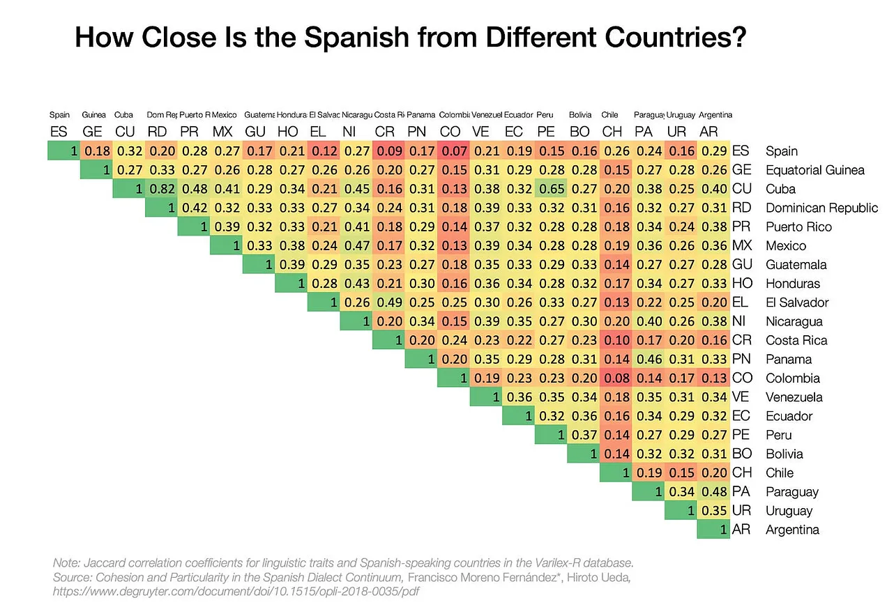
Er... if you look at the table (https://substackcdn.com/image/fetch/w_1272,c_limit,f_webp,q_...), Chile has quite a lot of red, but actually its Spanish is closer to the Spanish from Spain than that of other South American countries. So it looks like those have drifted further from "standard" Spanish, while Chile hasn't as much?
Chile has an Antarctic claim going all the way to the pole. If you consider that, it's impossible to go further south
If you don't, then we still just run out of land in the Continent. Note that the neighbour competition also applies to Tierra del Fuego, as we've had tensions with Argentina through history over the control of Magallanes Channel.
"el weon weon, weon."
Peru & Bolivia went to war with Chile for that region, but they lost in the War of the Pacific.
Why fight? Natural resources: guano and saltpeter.
Back then, guano was the world’s main fertilizer (and this area had most of the world's guano, thanks to the climate).
"""
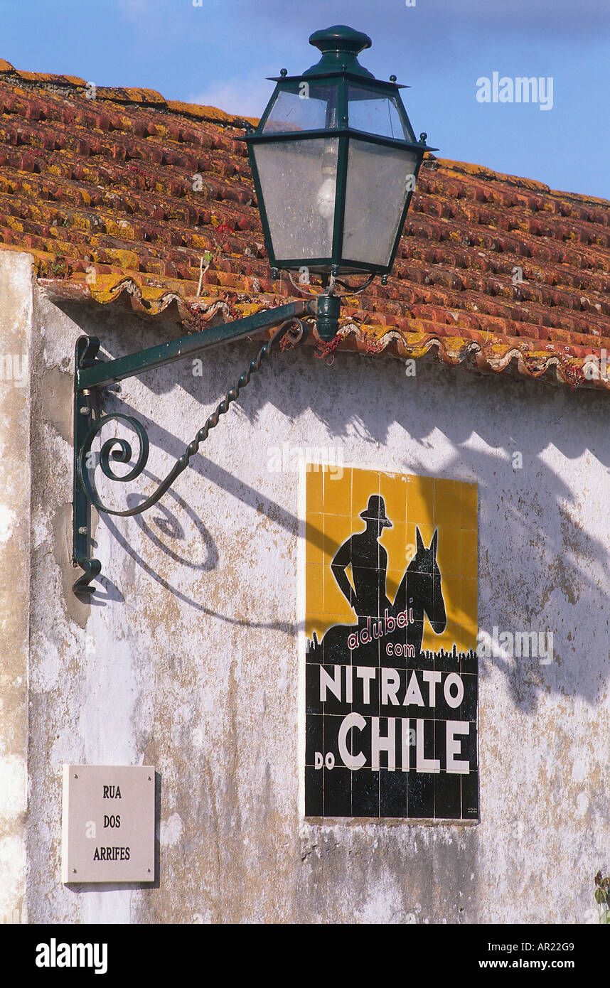
That fertilizer produced iconic advertising in mid XX Century Portugal and Spain: https://c8.alamy.com/comp/AR22G9/nitrato-de-chile-advertisin...
I never quite figured out what it meant.
As a native Spanish speaker, I find this quite interesting. For me, Chileans are within the category of "easy to understand" while I might struggle a bit understanding some accents that the article qualifies as easy or normal.
https://craigcalcaterra.com/blog/long-chile-ohio2-and-the-sn...
Also, I had no idea Chile is sooo long.
Technically New Zealand is the exposed portion of a continental sliver.
I miss the Inca though. Talking about Chile without mentioning the Inca Empire is like talking about Italy without mentioning the Roman Empire.
Looks like they're rating "difficulty" as "difference from Spanish in Spain". Considering that Spaniards only represent about 10% of the total Spanish-speaking population, I'm not sure that's fair.
See also “chilean empire map” (it’s not serious).
Related
Sifting Through the Debris of Another Failed Coup in Latin America
A failed coup attempt in Bolivia, led by former armed forces Commander General Juan José Zuñiga, aimed to change the cabinet and release ex-President Jeanine Áñez. President Luis Arce swiftly countered the coup, leading to arrests. Speculation points to US involvement due to historical interests in Latin America. Bolivia's lithium reserves and alliances with Russia and BRICS+ group add complexity. The incident highlights Bolivia's political instability and internal power conflicts.
Butterflies Flew 2,600 Miles Across the Atlantic Without Stopping
A group of painted lady butterflies from West Africa flew 2,600 miles to French Guiana with wind assistance. Researchers' decade-long study in Nature Communications reveals insights into insect migration aided by wind patterns.
Why do India and China keep fighting over this desolate terrain?
India and China's border conflicts in the Himalayas, including the Line of Actual Control disputes, reflect broader geopolitical rivalries. Recent clashes signal increased hostility, driven by military build-ups and power ambitions.
Norway blocks sale of last private land on Svalbard after Chinese interest
The Norwegian government blocks the sale of the last privately owned land on Svalbard to prevent Chinese acquisition. Concerns over sovereignty, resource exploitation, and geopolitical tensions drive the decision.
Venezuela is first Andean country to lose all of its glaciers
Venezuela loses its last glacier, the Humboldt Glacier, due to natural erosion and climate change. This event highlights global glacier shrinkage and the urgent call to address climate change's environmental impacts.